ဖုဲင်:AndamanSeaNASA1.jpg
နမူႏနာႏယို ပေႏတန်: ၄၇၅ × ၅၉၉ ပိစ်သယ်။ ပွုံႏယောင်ꩻစဲင်းစဲ့ အလင်ဖုံႏ: ၁၉၀ × ၂၄၀ ပိစ်သယ် | ၃၈၀ × ၄၈၀ ပိစ်သယ် | ၈၅၀ × ၁၀၇၂ ပိစ်သယ်။
မူလဖုဲင် (၈၅၀ × ၁၀၇၂ pixels, ဖုဲင်ပေႏတန် - ၂၄၆ KB, MIME အစွိုးအမျိုꩻ: image/jpeg)
အအဲဉ်ႏချုတ်
| အွဉ်ႏနယ်ချက် |
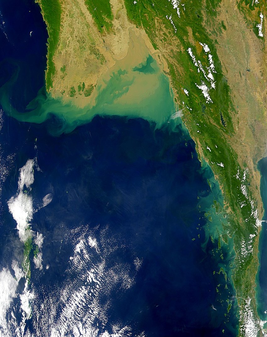
English: Satellite image of the Andaman Sea showing the green-algae and silt deposits due to the Irrawaddy River in its northern part |
| မွူးနီꩻ | |
| ရွီးခိုႏ | http://visibleearth.nasa.gov/view_rec.php?id=948 |
| တဲမ်းလိတ်သား | NASA |
အွောန်ႏထွော့လုဲင်သိဉ်
| This file is in the public domain in the United States because it was solely created by NASA. NASA copyright policy states that "NASA material is not protected by copyright unless noted". (See Template:PD-USGov, NASA copyright policy page or JPL Image Use Policy.) | ||
 |
Warnings:
|
ဖုဲင်မုဲင်တန်ꩻ
ဖေႏကထီႏလꩻ ဖုဲင်နဝ်ꩻမွူးနီꩻအတွိုင်ꩻနဝ်ꩻ နျꩻသွော့ မွူးနီꩻ/အခိန်ႏ တဗာႏဗာႏလောင်း ကလိစ်သြ။
| မွူးနီꩻ/အခိန်ႏ | နမူႏနာႏပွုံႏစံႏပေႏ | ဒုဲင်မဲဉ်းသိဉ်းဖုံႏ | ကေားသုင်ꩻသား | တောင်ꩻသေꩻ | |
|---|---|---|---|---|---|
| ယိုခါကျာꩻ | ၁၆:၃၅၊ ၁၄ သဲက်တဲဉ်ဗာ ၂၀၁၀ | | ၈၅၀ × ၁၀၇၂ (၂၄၆ KB) | Materialscientist | {{Information |Description={{en|1=Satellite image of the Andaman Sea showing the green-algae and silt deposits due to the Irrawaddy River in its northern part}} |Source=http://visibleearth.nasa.gov/view_rec.php?id=948 |Author=NASA |Date=1999-12-30 |Permi |
သုင်ꩻဖုဲင်
လိတ်မဲ့ငါလ့နဝ်ꩻနဝ်ꩻ အဝ်ႏသွုံꩻခါꩻ ဖုဲင်ယိုသွူ:
ဂလိုဗယ် သုင်ꩻဖုဲင်
ဝီခီအလင်ဖုံႏကို အဝ်ႏသွုံꩻခါꩻ ဖုဲင်ယိုသွူ:
- သုင်ꩻအီ af.wikipedia.org ကို
- သုင်ꩻအီ ar.wikipedia.org ကို
- သုင်ꩻအီ ast.wikipedia.org ကို
- သုင်ꩻအီ ba.wikipedia.org ကို
- သုင်ꩻအီ ca.wikipedia.org ကို
- သုင်ꩻအီ ceb.wikipedia.org ကို
- သုင်ꩻအီ cy.wikipedia.org ကို
- သုင်ꩻအီ el.wikipedia.org ကို
- သုင်ꩻအီ en.wikipedia.org ကို
- သုင်ꩻအီ eo.wikipedia.org ကို
- သုင်ꩻအီ es.wikipedia.org ကို
- သုင်ꩻအီ fr.wikipedia.org ကို
- သုင်ꩻအီ fy.wikipedia.org ကို
- သုင်ꩻအီ gl.wikipedia.org ကို
- သုင်ꩻအီ hak.wikipedia.org ကို
- သုင်ꩻအီ hy.wikipedia.org ကို
- သုင်ꩻအီ it.wikipedia.org ကို
- သုင်ꩻအီ mr.wikipedia.org ကို
- သုင်ꩻအီ ms.wikipedia.org ကို
- သုင်ꩻအီ mzn.wikipedia.org ကို
- သုင်ꩻအီ no.wikipedia.org ကို
- သုင်ꩻအီ oc.wikipedia.org ကို
- သုင်ꩻအီ pl.wikipedia.org ကို
- သုင်ꩻအီ ru.wikipedia.org ကို
- သုင်ꩻအီ sl.wikipedia.org ကို
- သုင်ꩻအီ sr.wikipedia.org ကို
- သုင်ꩻအီ th.wikipedia.org ကို
- သုင်ꩻအီ tr.wikipedia.org ကို
- သုင်ꩻအီ uk.wikipedia.org ကို
- သုင်ꩻအီ www.wikidata.org ကို