ဖုဲင်:England locator map with North East England highlighted.svg

Size of this PNG preview of this SVG file: ၄၉၄ × ၆၀၀ ပိစ်သယ်. ပွုံႏယောင်ꩻစဲင်းစဲ့ အလင်ဖုံႏ: ၁၉၈ × ၂၄၀ ပိစ်သယ် | ၃၉၅ × ၄၈၀ ပိစ်သယ် | ၆၃၂ × ၇၆၈ ပိစ်သယ် | ၈၄၃ × ၁၀၂၄ ပိစ်သယ် | ၁၆၈၆ × ၂၀၄၈ ပိစ်သယ် | ၈၁၆ × ၉၉၁ ပိစ်သယ်။
မူလဖုဲင် (SVG ဖုဲင်၊ ၈၁၆ × ၉၉၁ ပိစ်သယ်ဖေႏကျံႏညဏ်ႏဒျာႏ၊ ဖုဲင်ပေႏတန်: ၄၆၉ KB)
| အွဉ်ႏနယ်ချက် |
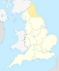
English: Equirectangular projection of England; North East England is highlighted. |
| မွူးနီꩻ | |
| ရွီးခိုႏ | File:England location map.svg |
| တဲမ်းလိတ်သား | |
| ဖေႏခွင်ꩻချက် (သုင်ꩻအီချာယင်း ဖုဲင်ယို) |
ဖုဲင်ယိုနဝ်ꩻ အွောန်ႏထွော့ခါꩻဒျာႏ တောမ်ႏ Creative Commons [[creativecommons
|
ဖုဲင်မုဲင်တန်ꩻ
ဖေႏကထီႏလꩻ ဖုဲင်နဝ်ꩻမွူးနီꩻအတွိုင်ꩻနဝ်ꩻ နျꩻသွော့ မွူးနီꩻ/အခိန်ႏ တဗာႏဗာႏလောင်း ကလိစ်သြ။
| မွူးနီꩻ/အခိန်ႏ | နမူႏနာႏပွုံႏစံႏပေႏ | ဒုဲင်မဲဉ်းသိဉ်းဖုံႏ | ကေားသုင်ꩻသား | တောင်ꩻသေꩻ | |
|---|---|---|---|---|---|
| ယိုခါကျာꩻ | ၁၆:၀၄၊ ၈ အေပီ ၂၀၁၀ | | ၈၁၆ × ၉၉၁ (၄၆၉ KB) | Jappalang | {{Information |Description=Equirectangular projection of England; Northumberland is highlighted |Source=File:England location map.svg |Date=2010-04-08 |Author=* File:England location map.svg: Spischot * author: [[User:Jappalang |
သုင်ꩻဖုဲင်
လိတ်မဲ့ငါလ့နဝ်ꩻနဝ်ꩻ အဝ်ႏသွုံꩻခါꩻ ဖုဲင်ယိုသွူ:
ဂလိုဗယ် သုင်ꩻဖုဲင်
ဝီခီအလင်ဖုံႏကို အဝ်ႏသွုံꩻခါꩻ ဖုဲင်ယိုသွူ:
- သုင်ꩻအီ am.wikipedia.org ကို
- သုင်ꩻအီ ar.wikipedia.org ကို
- သုင်ꩻအီ as.wikipedia.org ကို
- သုင်ꩻအီ bh.wikipedia.org ကို
- သုင်ꩻအီ bn.wikipedia.org ကို
- သုင်ꩻအီ bs.wikipedia.org ကို
- သုင်ꩻအီ ca.wikipedia.org ကို
- သုင်ꩻအီ cy.wikipedia.org ကို
- သုင်ꩻအီ da.wikipedia.org ကို
- သုင်ꩻအီ diq.wikipedia.org ကို
- သုင်ꩻအီ dty.wikipedia.org ကို
- သုင်ꩻအီ dv.wikipedia.org ကို
- သုင်ꩻအီ en.wikipedia.org ကို
- Template:Location map+
- Template:Location map~
- Template:Location map+/doc
- Template:Location map+/sandbox
- Template:Location map+/testcases
- Template:Location map~/sandbox
- Template:Location map+/AlternativeMap
- User:Arjunaraoc/sandbox/SampleMap1
- User:Arjunaraoc/sandbox/SampleMap2
- User:Arjunaraoc/sandbox/SampleMap3
- သုင်ꩻအီ en.wikibooks.org ကို
- သုင်ꩻအီ en.wikiversity.org ကို
- သုင်ꩻအီ fa.wikipedia.org ကို
နွို့ထွား ကသုင်ꩻခါꩻအီဒါႏဖုဲင်ယို ခင်ႏလမ်းအလင်ဖုံႏကို။