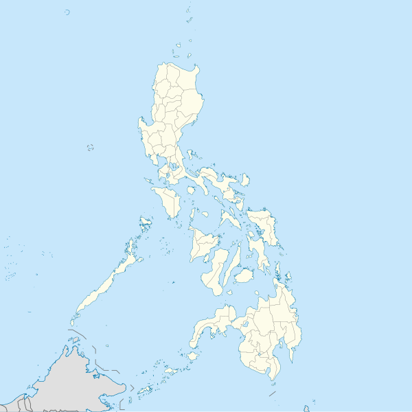
ဖုဲင်:Philippines location map (square).svg

Size of this PNG preview of this SVG file: ၆၀၀ × ၆၀၀ ပိစ်သယ်. ပွုံႏယောင်ꩻစဲင်းစဲ့ အလင်ဖုံႏ: ၂၄၀ × ၂၄၀ ပိစ်သယ် | ၄၈၀ × ၄၈၀ ပိစ်သယ် | ၇၆၈ × ၇၆၈ ပိစ်သယ် | ၁၀၂၄ × ၁၀၂၄ ပိစ်သယ် | ၂၀၄၈ × ၂၀၄၈ ပိစ်သယ် | ၁၃၃၂ × ၁၃၃၂ ပိစ်သယ်။
မူလဖုဲင် (SVG ဖုဲင်၊ ၁၃၃၂ × ၁၃၃၂ ပိစ်သယ်ဖေႏကျံႏညဏ်ႏဒျာႏ၊ ဖုဲင်ပေႏတန်: ၁.၄၉ MB)
ဖုဲင်မုဲင်တန်ꩻ
ဖေႏကထီႏလꩻ ဖုဲင်နဝ်ꩻမွူးနီꩻအတွိုင်ꩻနဝ်ꩻ နျꩻသွော့ မွူးနီꩻ/အခိန်ႏ တဗာႏဗာႏလောင်း ကလိစ်သြ။
| မွူးနီꩻ/အခိန်ႏ | နမူႏနာႏပွုံႏစံႏပေႏ | ဒုဲင်မဲဉ်းသိဉ်းဖုံႏ | ကေားသုင်ꩻသား | တောင်ꩻသေꩻ | |
|---|---|---|---|---|---|
| ယိုခါကျာꩻ | ၁၆:၄၇၊ ၁၉ ဩဂဲစ် ၂၀၂၁ |  | ၁၃၃၂ × ၁၃၃၂ (၁.၄၉ MB) | AichiWikiFixer | Updated boundaries |
| ၁၄:၂၃၊ ၁၈ ဇွန် ၂၀၂၁ |  | ၁၃၃၂ × ၁၃၃၂ (၂.၂၄ MB) | AichiWikiFixer | Map update. | |
| ၁၀:၂၅၊ ၁၈ ဇွန် ၂၀၂၁ |  | ၁၃၃၂ × ၁၃၃၂ (၂.၂၃ MB) | AichiWikiFixer | Small changes. | |
| ၁၀:၁၉၊ ၁၈ ဇွန် ၂၀၂၁ |  | ၁၃၃၂ × ၁၃၃၂ (၂.၂၃ MB) | AichiWikiFixer | External changes for boundaries and coastlines. | |
| ၁၉:၄၁၊ ၁၇ ဇွန် ၂၀၂၁ |  | ၁၃၃၂ × ၁၃၃၂ (၂.၂၃ MB) | AichiWikiFixer | Additional islands, lakes, and updated coastlines. | |
| ၁၇:၀၄၊ ၁၇ ဇွန် ၂၀၂၁ |  | ၁၃၃၂ × ၁၃၃၂ (၂.၂၃ MB) | AichiWikiFixer | Update boundaries. | |
| ၀၈:၃၄၊ ၂၅ မေ ၂၀၂၁ |  | ၁၃၃၂ × ၁၃၃၂ (၂.၂၂ MB) | HueMan1 | Reverted to version as of 07:24, 7 September 2020 (UTC) | |
| ၁၃:၄၁၊ ၁၇ မေ ၂၀၂၁ |  | ၁၃၃၂ × ၁၃၃၂ (၃.၇၂ MB) | Petriolo | Reverted to version as of 05:36, 3 May 2021 (UTC) The new administrative borders are based from the Philippine government websites (https://www.geoportal.gov.ph/; http://noah.up.edu.ph/), and is deemed accurate. These new files have reliable sources and there's no "beauty" in it if it is inaccurate in the first place. | |
| ၂၀:၃၀၊ ၁၆ မေ ၂၀၂၁ |  | ၁၃၃၂ × ၁၃၃၂ (၂.၂၂ MB) | AichiWikiFixer | Reverted to version as of 07:24, 7 September 2020 (UTC) (Borders seen as ugly) | |
| ၁၂:၀၆၊ ၃ မေ ၂၀၂၁ |  | ၁၃၃၂ × ၁၃၃၂ (၃.၇၂ MB) | Petriolo | updated with NAMRIA borders |
သုင်ꩻဖုဲင်
ဖုဲင်ယိုနဝ်ꩻ သွုံꩻခါꩻဒါႏ လိတ်မဲ့ငါဖုံႏ အဝ်ႏတဝ်းသွူ။
ဂလိုဗယ် သုင်ꩻဖုဲင်
ဝီခီအလင်ဖုံႏကို အဝ်ႏသွုံꩻခါꩻ ဖုဲင်ယိုသွူ:
- သုင်ꩻအီ af.wikipedia.org ကို
- သုင်ꩻအီ ar.wikipedia.org ကို
- သုင်ꩻအီ arz.wikipedia.org ကို
- သုင်ꩻအီ ast.wikipedia.org ကို
- Asturias (Filipines)
- Toboso
- Lucena (Filipines)
- Alcala
- Manila
- Módulu:Mapa de llocalización/datos/Filipines
- Mar de Joló
- Luzón
- Komisyon sa Wikang Filipino
- Mar de Visayas
- Mindanao
- Lingayén
- Tarlac
- Vigan
- Arrozales en terraces de los cordales de Filipines
- Dávao
- Complexu del Batasang Pambansa
- Ríu Pásig
- Estrechu de Mindoro
- Estrechu de Luzón
- Islles de Calamianes
- Módulu:Mapa de llocalización/datos/Filipines/usu
- Aeropuertu Internacional Ninoy Aquino
- Pasay
- Parañaque
- Universidá de Bulacán
- Aeropuertu Daniel Z. Romuáldez
- Aeropuertu Evelio Javier
- Aeropuertu Francisco B. Reyes
- Aeropuertu Godofredo P. Ramos
- Aeropuertu d'Awang
- Aeropuertu de Bancasi
- Aeropuertu de Dipolog
- Aeropuertu d'Ipil
- Aeropuertu de Joló
- Aeropuertu de Labo
- Aeropuertu de Laguindingán
- Aeropuertu de Lumbia
- Aeropuertu de Naga
- Aeropuertu de Pagadían
နွို့ထွား ကသုင်ꩻခါꩻအီဒါႏဖုဲင်ယို ခင်ႏလမ်းအလင်ဖုံႏကို။